Forget paintbrushes and easels.
NASA and other satellites that capture photographs of Earth from space are producing stunning works of abstract art.
Some of the most striking images are included in the United States Geological Survey (USGS)’s Earth as Art program. It was launched in 2002 to educate the public about satellite imagery that assists scientific research.
The images also have caught the eye of Brent Yantis, director of the University of Louisiana at Lafayette’s Regional Application Center. He has been involved with several UL Lafayette projects to assemble gallery exhibits of NASA and other satellite images.
The latest collection includes about 35 images on canvas and gallery panels. The exhibit was curated by Regional Application Center staff members, and students from the School of Architecture and Design. Images were selected based on aesthetic qualities such as color, tone and clarity.
The free exhibit will be displayed until July 12 at The Gallery at Manship Theatre at Shaw Center for the Arts in Baton Rouge.
It provides a compelling view of the intersection of art and science.
Scientists rely on satellite images to document changes to the Earth’s topography, and research its features such as glaciers, deserts or rivers. The vivid colors that illustrate the contours of continents, islands, mountains, coastlines, or rivers, on the other hand, can form the foundation of beautiful images.
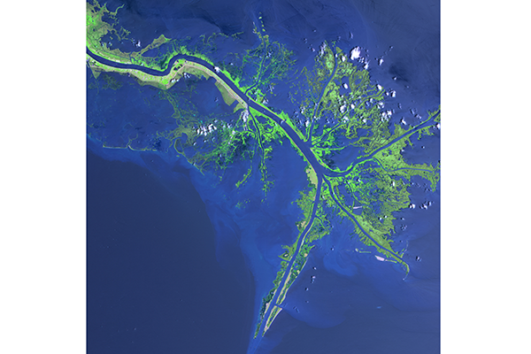
The exhibit enables viewers to learn about dozens of places across the planet, including volcanoes in Mexico, deserts in Africa, or the Mississippi Delta. It also teaches students about remote sensing technology, which records the satellite images.
“The exhibit provides a fun, interactive way to learn about the planet, and the science behind remote sensing and geographical information systems,” Yantis explained.
UL Lafayette is a supporting sponsor for the exhibit. The Louisiana Remote Sensing and Geographic Information Systems Institute is the main sponsor along with AmericaView and USGS.
Learn more about the exhibit at http://www.larsgisinstitute.org/
Photo info: Images of the Earth’s surface that were captured from space by satellites are part of a gallery exhibit that was curated by researchers and students at the University of Louisiana at Lafayette. The exhibit enables viewers to learn about the planet, including the Mississippi Delta (shown), volcanoes in Mexico, or deserts in Africa.